


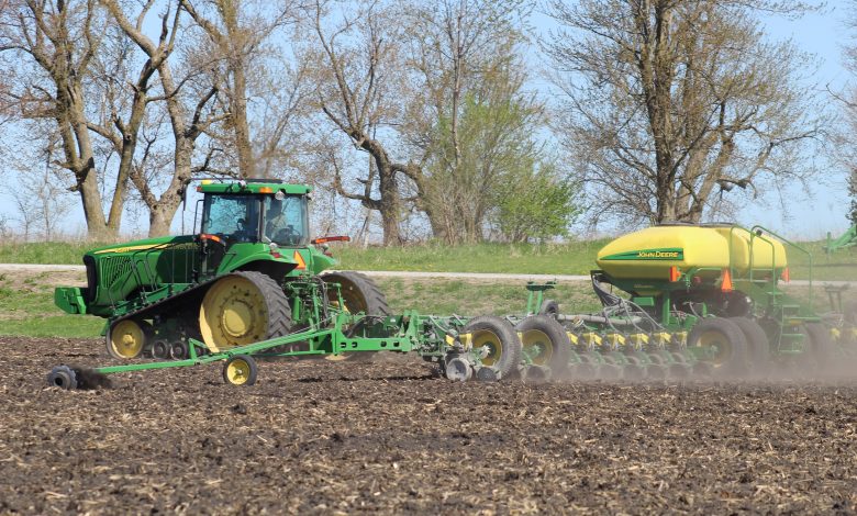
Snow, high winds, and continued cold conditions limited Iowa farmers to 2.8 days suitable for fieldwork during the week ending April 17, 2022, according to the USDA, National Agricultural Statistics Service. Farmers have been applying anhydrous and fertilizer, spreading manure, tilling fields, and planting oats where possible while preparing to plant row crops.
Topsoil moisture condition rated 7 percent very short, 22 percent short, 66 percent adequate and 5 percent surplus. Subsoil moisture condition rated 11 percent very short, 33 percent short, 54 percent adequate and 2 percent surplus.
Twenty-nine percent of the expected oat crop has been planted, 8 days behind last year and 3 days behind the 5- year average. Oats are beginning to emerge across the State.
Pastures were still mostly dormant although there were reports of some starting to turn green. Livestock conditions were generally good, with many new calves arriving.
IOWA PRELIMINARY WEATHER SUMMARY
Provided by Justin Glisan, Ph.D., State Climatologist
Iowa Department of Agriculture and Land Stewardship
Reports from the Iowa Department of Agriculture and Land Stewardship and maps from the Midwestern Regional Climate Center reflect data collected from 7:00 A.M. Central Time on April 11, 2022, through 7:00 A.M. Central Time on April 17, 2022.
Severe weather returned early last week with eight tornadoes reported across northern Iowa, the strongest having winds of up to 135 mph. While rainfall accompanied the disturbance that produced these strong thunderstorms, much of eastern and northwestern Iowa observed drier than normal conditions. Overall temperatures were also warmer than the previous reporting period, though up to eight degrees below normal in the northwest; the statewide average temperature was 42.1 degrees, 6.2 degrees below normal.
Very windy conditions continued through Sunday (10th) afternoon as a low pressure center pushed across northern Iowa. Winds shifted from the southeast to a westerly direction as daytime temperatures rose into the upper 60s and low 70s at many stations; upper 70s were observed in south-central Iowa. Overnight temperatures into Monday (11th) ranged from the upper 20s northwest to low 40s southeast under cloudless skies. Pleasant conditions persisted through the afternoon hours with above-average daytime highs in the low to mid 60s. Skies remained clear early into Tuesday (12th) morning, though cloudy conditions began to develop in western Iowa by sunrise as a potent weather system approached Iowa. Southeasterly winds in the 20 to 30 mph range pumped in warm, moist air ahead of a strong cold front; a warm front moving north across southeastern Iowa pushed temperatures into the 80s within the warm sector of the strong low pressure system. The mix of unseasonably warm air, atmospheric instability and wind shear over northern Iowa fired supercell thunderstorms late in the afternoon. Several of these storms produced tornadoes with a stronger EF-2 that moved through Gilmore City (Humboldt County), producing damage to multiple farms. As the cold front swept across Iowa during the late afternoon and evening hours, a second round of severe weather impacted western Iowa with many reports of large hail and strong straight-line winds. The line lost energy overnight as it pushed east, though moderate rain was observed. Rain totals reported at 7:00 am on Wednesday (13th) were highest in north-central Iowa with nine stations measuring over an inch; much of the western half of Iowa reported totals between 0.25 to 0.75 inch. Light showers lingered through the day as temperatures lingered in the mid 30s to mid 40s.
Gusty westerly winds built in overnight into Thursday (14th) with wind speeds increasing into the 30-40 mph range through the day; Estherville Municipal Airport (Emmet County) observed a wind gust of 61 mph. Afternoon highs were in the upper 30s north to low 50s south, where skies were clear. Partly cloudy skies developed into early Friday (15th) morning as winds eased and shifted to the northwest with temperatures in the mid to upper 40s observed in the afternoon. Clouds moved out lending to mostly sunny conditions over Iowa on Saturday (16th) with chilly morning temperatures; the statewide average low was 25 degrees, 12 degrees below normal. Temperatures rose into the upper 40s and low 50s in southern Iowa while readings were up to 10 degrees cooler in the north. An approaching disturbance brought thick stratus clouds into western Iowa into Sunday (17th) morning with winds turning to an easterly direction. Low temperatures varied from the low 20s in eastern Iowa to mid 30s in the west under clouds.
Weekly precipitation totals ranged from no accumulation at several northwest Iowa stations to 4.50 inches at St. Ansgar (Mitchell County). The statewide weekly average precipitation was 0.41 inch while the normal is 0.79 inch. Little Sioux (Harrison County) reported the week’s high temperature of 90 degrees on the 12th, on average 29 degrees above average. Primghar (O’Brien County) and Sioux City (Woodbury County) reported the week’s low temperature of 16 degrees on the 16th, on average 20 degrees below normal. Four-inch soil temperatures were in the upper 30s northeast to mid 40s southwest as of Sunday.