


Geographic Technology Provides Landowners with Precise Tools When Making Land Management Decisions
As soil temperatures warm and planting continues, landowners across the state are faced with decisions as critical and multi-faceted as the land itself. While Iowa’s topography may not be as dynamic as in some states, even minute differences throughout a field can be augmented by the flow of water and wind.
According to Lee Burras and Bradley Miller, agronomists at Iowa State University, advances in geospatial technology coupled with more traditional farming knowledge have allowed researchers and landowners to understand the land more intimately than ever before.
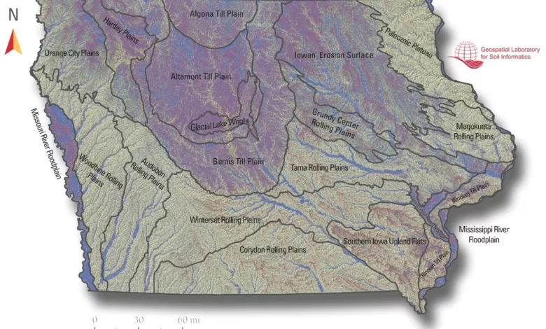
Insight into Miller’s research is available on Iowa State’s Geospatial Laboratory for Soil Informatics, which provides more information and resources regarding integrating geospatial technology and traditional soil science.
Miller, who began his career working in water quality, has seen firsthand how soil can be impacted by the flow of water across a field. As he explains, water flow across a field is largely determined by the broader landscape of the field.
“Working in water quality, I began to really realize that in order to understand water quality issues, we need to understand the landscape where the water flows through, including the land use for that soil,” he said.
However, he quickly realized that the resources available to researchers such as himself and the landowners impacted by these issues were somewhat behind the times. “The soil maps we had weren’t quite good enough to meet our needs,” he explained, “so from there, I became a geographer.”
Using geospatial technology has provided Miller with unique insight into fields and soils, as it gives him the ability to analyze patterns in the land to predict where different soil properties exist throughout a field. This insight becomes especially powerful when coupled with more ‘traditional’ knowledge surrounding soil productivity and conservation, ideas Burras is well-versed in.
“Everyone who is attempting to grow something in Iowa is attempting to grow something in a certain place,” Burras explained, “so the first thing you want to do is know the soil in its place. Is the landscape a hill? A valley? How deep is the A-horizon, or the black, organic soil zone?”
By analyzing these soil properties, agronomists and landowners can better understand how to increase yields and mitigate environmental impacts.
“Each root in a field is experiencing a different environment,” said Burras. “Ultimately, the farmer is trying to maximize yield, and with modern geographic technology, we can manage things like seeding rates and fertility in a more and more refined way. What may seem like a small difference from a traditional mapping point of view can make a big difference at the root zone of the crop.”
Although technology can serve as a powerful tool, the wealth of knowledge possessed by farmers also plays an important role in land management decisions.
“Farmers are really good about knowing their fields,” said Miller. “Even if they don’t fully know why, working fields year after year allows farmers to see the differences in soil, so they start making inferences about where that variation is.”
For more information on geospatial technology and soil science, visit https://glsi.agron.iastate.edu/or contact Miller at [email protected]. For more information on Iowa’s soils, visit the Iowa State University Extension Store.